CDO remapping help
Added by Carlee Loeser over 5 years ago
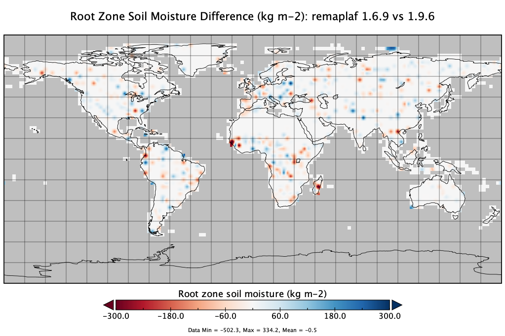
At NASA Goddard, we make extensive use of the remapping functions that CDO provides. We have noticed that between v1.6.9 and v1.9.6, the output of some of the remapping functions has changed. I didn’t see anything in the release notes that would indicate such a change. If possible, could you please provide any information on the changes that were made to these functions so that we can explain to our users if/when they notice differences in their output. The biggest differences were with the remapdis, and I can provide difference plots if that helps.
Replies (4)
RE: CDO remapping help - Added by Uwe Schulzweida over 5 years ago
We have essentially replaced the search method to improve the performance. The new 3D method is a bit more accurate, the old 2D method can lead to inaccuracies at the poles. In principle, however, the same results should be produced, and they were in our tests as well.
We need your data and the CDO commandline to investigate this problem. Could you provide us with some?
Cheers,
Uwe
RE: CDO remapping help - Added by Carlee Loeser over 5 years ago
Hi Uwe,
Thank you for your reply.
Here are the CDO commands --
For version 1.6.9:
cdo -s -L -f nc4 -remaplaf,cfsr2.5.grid -selname,RootMoist_inst,SWdown_f_tavg,Rainf_tavg,Psurf_f_inst,Evap_tavg GLDAS_NOAH025_3H.A19730903.1500.020.nc4 GLDAS_NOAH025_3H.A19730903.1500.020.cdov1.6.9.nc4
For version 1.9.7:
cdo -P 8 -s -L -f nc4 -z zip_4 -remaplaf,cfsr2.5.grid -selname,RootMoist_inst,SWdown_f_tavg,Rainf_tavg,Psurf_f_inst,Evap_tavg GLDAS_NOAH025_3H.A19730903.1500.020.nc4 GLDAS_NOAH025_3H.A19730903.1500.020.cdov1.9.7.nc4
The data file is available for download here: https://hydro1.gesdisc.eosdis.nasa.gov/data/GLDAS/GLDAS_NOAH025_3H.2.0/1973/246/GLDAS_NOAH025_3H.A19730903.1500.020.nc4
I have attached the gridded file cfsr2.5.grid. It is in netCDF format.
I have also updated a difference map between both output files for the RootMoist_inst variable.
RE: CDO remapping help - Added by Carlee Loeser over 5 years ago
I should have mentioned before - to access NASA GES DISC data, an Earthdata account is needed. This is free with instructions here: https://disc.gsfc.nasa.gov/data-access.
Sorry for the inconvenience.
RE: CDO remapping help - Added by Uwe Schulzweida over 5 years ago
Thanks for the data!
In your example, a target cell contains about 10x10 source cells. So there are about 10 cells in the direction of the longitudes, which all have about the same area. If all these 10 cells have different values, then potentially all of them will be considered correct.
The result of the calculation of the area can differ in the accuracy of the calculation. If the calculation is slightly different, another of these 10 cells will always be minimally larger.
As in the present case, this can lead to completely different results.
In principle, it is similar to searching for the nearest neighbor.
If 10 values have the same distance, the result depends on the calculation of the distance.