Convert COSMO REA 6 to a normal geographical projection
Added by Zhongyang Hu over 7 years ago
Hi there,
I am currently using the REA 6 data, how ever I found the data is of a rotated longitude-latitude grid with a shifted pole.
I tried cdo remapbil function, with the parameters provided by the:
COSMO-REA6 Starting Example, ftp://ftp-cdc.dwd.de/pub/REA/COSMO_REA6/help_COSMO_REA6/COSMO_REA6_Starting_example.pdf
However, once I display the results in arcgis/qgis the results are still in Africa, could somebody help me.
I also displayed COSMO_REA6_CONST_withOUTsponge.nc file, it is also shifted to Africa.
Thanks in advance,
Young
Replies (31)
RE: Convert COSMO REA 6 to a normal geographical projection - Added by JUHI DHURIYA almost 3 years ago
Karin Meier-Fleischer wrote in RE: Convert COSMO REA 6 to a normal geographical projection:
That is the WAS-44i domain.
[...]
Maybe you have to delete the 'scanningMode = 64' line in your grid description file. It should work.
Okay, thank you, Karin.
Regards
Juhi
RE: Convert COSMO REA 6 to a normal geographical projection - Added by JUHI DHURIYA almost 3 years ago
Hello Karin,
I'm still facing some issues. I'm using WAS-44 cordex domain precipitation data, which is pr_WAS-44_NOAA-GFDL-GFDL-ESM2M_historical_r1i1p1_SMHI-RCA4_v2_day_19510101-19551231.nc in rotated pole coordinate and I need to convert it into Regular geographic grids.
Here is the cdo sinfo output of the NetCDF file.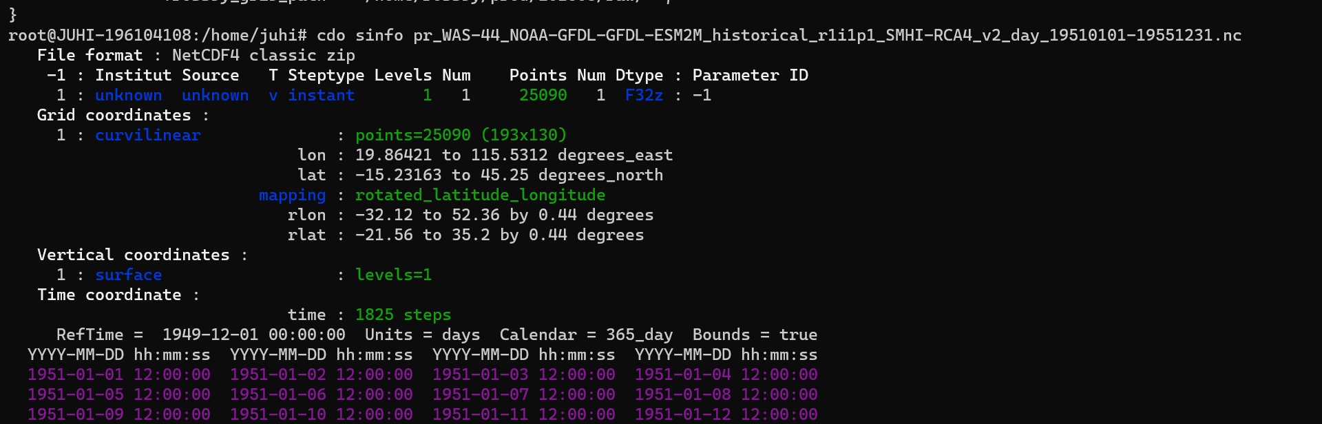
I used the grid text you provided for the conversion of the data, but the converted netcdf file doesn't align with the my countries shapefile when I'm opening it in arcgis.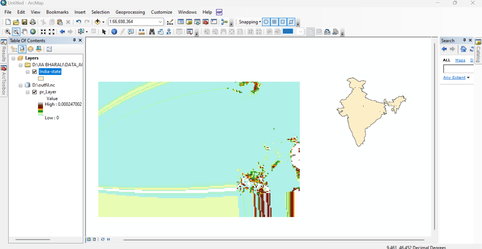
So should I be using the below grid text file
gridtype = lonlat
gridsize = 24180
xsize = 195
ysize = 124
xname = lon
xlongname = "longitude"
xunits = "degrees_east"
yname = lat
ylongname = "latitude"
yunits = "degrees_north"
xfirst = 19.25
xinc = 0.44
yfirst = -15.75
yinc = 0.44
grid_mapping = rotated_pole
grid_mapping_name = rotated_latitude_longitude
grid_north_pole_latitude = 0.5
grid_north_pole_longitude = 0.5
based on the WAS-44i domain, which is in a regular coordinate system, or does the grid text provided by you need some changes?
Regards
Juhi
| sinfo.png (86.8 KB) sinfo.png | |||
| arcgis.png (254 KB) arcgis.png |
RE: Convert COSMO REA 6 to a normal geographical projection - Added by Karin Meier-Fleischer almost 3 years ago
Did you try my first guess of the grid description file for WAS-44?
Please, upload your WAS-44 data file to https://nextcloud.dkrz.de/s/dYmEzxGG4qKDz9S
RE: Convert COSMO REA 6 to a normal geographical projection - Added by JUHI DHURIYA almost 3 years ago
Hi Karin,
Yes, I used the grid description provided by you and obtained the output file. When I added the output file in ArcGIS with the shapefile of the domain, they were not aligned, which means the conversion was wrong.
Here I've attached the image of the output in ArcGIS.
Moreover, I've uploaded the NetCDF file in the link that you have sent.
Regards,
Juhi
| arcgis.png (254 KB) arcgis.png |
RE: Convert COSMO REA 6 to a normal geographical projection - Added by Karin Meier-Fleischer almost 3 years ago
Ok, now I got it.
gridfile_WAS-44.txt used the :
gridtype  = lonlat
gridsize  = 25090
xsize     = 193
ysize     = 130
xname     = lon
xlongname = "longitude"
xunits    = "degrees_east"
yname     = lat
ylongname = "latitude"
yunits    = "degrees_north"
xfirst    =  19.25
xinc      = 0.5
yfirst    =  -15.75
yinc      = 0.5
grid_mapping = rotated_pole
grid_mapping_name = rotated_latitude_longitude
grid_north_pole_latitude = 79.95
grid_north_pole_longitude = 236.66
Remap:
cdo -sellonlatbox,0.,360.,-90.,90. -remapbil,gridfile_WAS-44.txt pr_WAS-44_NOAA-GFDL-GFDL-ESM2M_historical_r1i1p1_SMHI-RCA4_v2_day_19510101-19551231.nc outfile.nc
cdo sinfon outfile.nc
   File format : NetCDF4 classic
    -1 : Institut Source   T Steptype Levels Num    Points Num Dtype : Parameter name
     1 : unknown  unknown  v instant       1   1     25090   1  F32  : pr
   Grid coordinates :
     1 : lonlat                   : points=25090 (193x130)
                              lon : 19.25 to 115.25 by 0.5 degrees_east
                              lat : -15.75 to 48.75 by 0.5 degrees_north
   Vertical coordinates :
     1 : surface                  : levels=1
   Time coordinate :
                             time : 1825 steps
     RefTime =  1949-12-01 00:00:00  Units = days  Calendar = 365_day  Bounds = true
  YYYY-MM-DD hh:mm:ss  YYYY-MM-DD hh:mm:ss  YYYY-MM-DD hh:mm:ss  YYYY-MM-DD hh:mm:ss
  1951-01-01 12:00:00  1951-01-02 12:00:00  1951-01-03 12:00:00  1951-01-04 12:00:00
  ...
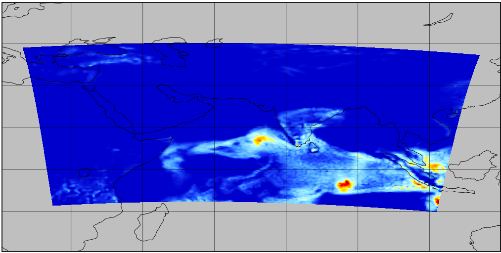
Compare original with remapping result:
Original:
Remapped:
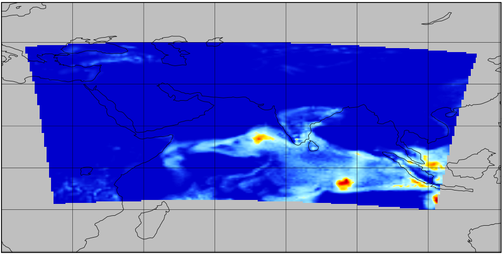
| remapped.png (184 KB) remapped.png | |||
| original.png (198 KB) original.png |
RE: Convert COSMO REA 6 to a normal geographical projection - Added by JUHI DHURIYA almost 3 years ago
Hi Karin,
I got it now; the conversion aligns with the study area. Thank you
regards,
Juhi
- « Previous
- 1
- 2
- Next »