remapbil and issues with high latitudes
Added by Paolo Davini about 13 years ago
Hi to All,
I am trying to interpolate the ECMWF ERA40 data from the N80 grid to a regular lonlat 2.5x2.5 grid.
Once the remap is performed, I check the differences between the interpolated data and the ERA40 field downloaded on the 2.5 grid directly from the ECMWF website.
I found not negligible differences between the two, and I am not able to understand why.
I uses the whole set of remap function (remapcon produce best agreement), but especially remapbil gives me large differences at high latitudes.
The command I use is "cdo rempabil,destination_grid.txt file_N80.nc file_2.5.nc"
Here below I reported the griddes output for the original and interpolated grid, and for the diff command in the end. The file analyzed is U850, ERA40 Reanalysis, January 2000.
If you need it, I am able to upload the above-mentioned files.
Many thanks to everyone.
Best Regards
Paolo Davini
- gridID 0
#
gridtype = gaussian
gridsize = 51200
xname = longitude
xlongname = longitude
xunits = degrees_east
yname = latitude
ylongname = latitude
yunits = degrees_north
xsize = 320
ysize = 160
xfirst = 0
xinc = 1.125
yvals = 89.1415176 88.0294266 86.9107742 85.7906265 84.6699219 83.5489502 82.4278183
81.3065948 80.1853104 79.0639801 77.942627 76.8212433 75.6998444 74.5784302
73.4570084 72.3355789 71.2141342 70.0926895 68.9712372 67.8497849 66.7283249
65.6068649 64.4853973 63.3639336 62.2424622 61.1209908 59.9995193 58.8780441
57.7565689 56.6350937 55.5136147 54.3921356 53.2706566 52.1491737 51.0276947
49.9062119 48.784729 47.6632462 46.5417633 45.4202805 44.2987938 43.1773109
42.0558243 40.9343376 39.812851 38.6913643 37.5698814 36.448391 35.3269043
34.2054176 33.083931 31.9624443 30.8409557 29.7194672 28.5979786 27.47649
26.3550034 25.2335148 24.1120243 22.9905357 21.8690472 20.7475586 19.62607
18.5045795 17.383091 16.2616005 15.1401119 14.0186224 12.8971329 11.7756433
10.6541529 9.53266335 8.41117382 7.2896843 6.16819429 5.04670429 3.92521453
2.80372477 1.68223488 0.560744941 -0.560744941 -1.68223488 -2.80372477
-3.92521453 -5.04670429 -6.16819429 -7.2896843 -8.41117382 -9.53266335
-10.6541529 -11.7756433 -12.8971329 -14.0186224 -15.1401119 -16.2616005
-17.383091 -18.5045795 -19.62607 -20.7475586 -21.8690472 -22.9905357
-24.1120243 -25.2335148 -26.3550034 -27.47649 -28.5979786 -29.7194672
-30.8409557 -31.9624443 -33.083931 -34.2054176 -35.3269043 -36.448391
-37.5698814 -38.6913643 -39.812851 -40.9343376 -42.0558243 -43.1773109
-44.2987938 -45.4202805 -46.5417633 -47.6632462 -48.784729 -49.9062119
-51.0276947 -52.1491737 -53.2706566 -54.3921356 -55.5136147 -56.6350937
-57.7565689 -58.8780441 -59.9995193 -61.1209908 -62.2424622 -63.3639336
-64.4853973 -65.6068649 -66.7283249 -67.8497849 -68.9712372 -70.0926895
-71.2141342 -72.3355789 -73.4570084 -74.5784302 -75.6998444 -76.8212433
-77.942627 -79.0639801 -80.1853104 -81.3065948 -82.4278183 -83.5489502
-84.6699219 -85.7906265 -86.9107742 -88.0294266 -89.1415176
- gridID 0
#
gridtype = lonlat
gridsize = 10512
xname = lon
xlongname = Longitude
xunits = degrees_east
yname = lat
ylongname = Latitude
yunits = degrees_north
xsize = 144
ysize = 73
xfirst = 0
xinc = 2.5
yfirst = 90
yinc = -2.5
DIFF
Date Time Param Level Size Miss : S Z Max_Absdiff Max_Reldiff
1 : 2000-01-01 18:00:00 131.128 85000 10512 0 : T F 12.809 0.99929
2 : 2000-01-02 18:00:00 131.128 85000 10512 0 : T F 13.154 0.99944
3 : 2000-01-03 18:00:00 131.128 85000 10512 0 : T F 22.115 0.99550
4 : 2000-01-04 18:00:00 131.128 85000 10512 0 : T F 20.960 0.99826
5 : 2000-01-05 18:00:00 131.128 85000 10512 0 : T F 21.271 0.99825
6 : 2000-01-06 18:00:00 131.128 85000 10512 0 : T F 21.536 0.99386
7 : 2000-01-07 18:00:00 131.128 85000 10512 0 : T F 20.775 0.99369
8 : 2000-01-08 18:00:00 131.128 85000 10512 0 : T F 18.499 0.99854
9 : 2000-01-09 18:00:00 131.128 85000 10512 0 : T F 18.249 0.99647
10 : 2000-01-10 18:00:00 131.128 85000 10512 0 : T F 21.829 0.99983
11 : 2000-01-11 18:00:00 131.128 85000 10512 0 : T F 24.329 0.99865
12 : 2000-01-12 18:00:00 131.128 85000 10512 0 : T F 25.187 0.99926
13 : 2000-01-13 18:00:00 131.128 85000 10512 0 : T F 14.856 0.99831
14 : 2000-01-14 18:00:00 131.128 85000 10512 0 : T F 6.5246 0.99868
15 : 2000-01-15 18:00:00 131.128 85000 10512 0 : T F 7.2223 0.99923
16 : 2000-01-16 18:00:00 131.128 85000 10512 0 : T F 8.1705 0.99607
17 : 2000-01-17 18:00:00 131.128 85000 10512 0 : T F 10.940 0.99961
18 : 2000-01-18 18:00:00 131.128 85000 10512 0 : T F 7.7274 0.99876
19 : 2000-01-19 18:00:00 131.128 85000 10512 0 : T F 8.0440 0.99774
20 : 2000-01-20 18:00:00 131.128 85000 10512 0 : T F 8.3870 0.99823
21 : 2000-01-21 18:00:00 131.128 85000 10512 0 : T F 8.3537 0.99861
22 : 2000-01-22 18:00:00 131.128 85000 10512 0 : T F 15.087 0.99878
23 : 2000-01-23 18:00:00 131.128 85000 10512 0 : T F 13.339 0.99970
24 : 2000-01-24 18:00:00 131.128 85000 10512 0 : T F 9.5025 0.99909
25 : 2000-01-25 18:00:00 131.128 85000 10512 0 : T F 9.1003 0.99619
26 : 2000-01-26 18:00:00 131.128 85000 10512 0 : T F 6.2108 0.99727
27 : 2000-01-27 18:00:00 131.128 85000 10512 0 : T F 12.605 0.99529
28 : 2000-01-28 18:00:00 131.128 85000 10512 0 : T F 13.249 0.99821
29 : 2000-01-29 18:00:00 131.128 85000 10512 0 : T F 11.099 0.99630
30 : 2000-01-30 18:00:00 131.128 85000 10512 0 : T F 25.890 0.99809
31 : 2000-01-31 18:00:00 131.128 85000 10512 0 : T F 21.840 0.99594
31 of 31 records differ
Replies (5)
RE: remapbil and issues with high latitudes - Added by Uwe Schulzweida about 13 years ago
Hi Paolo,
As far as I know the ECMWF data on the 2.5 grid has been directly interpolated from the original Gaussian reduced N80 grid. Your N80 data is already converted from the reduced N80 grid to a regular N80 grid.
Cheers,
Uwe
RE: remapbil and issues with high latitudes - Added by Paolo Davini about 13 years ago
Dear Uwe,
Many thanks for the prompt answer. Therefore you are suggesting that the convertion from reduced to linear gaussian grid can explain the differences I get? If this is true, this would raise a more "scientific" question: since the differences are not neglibigle, is it "correct" to perform the interpolation I am doing? If yes, what version of the data (the original 2.5 or my self-interpolate 2.5) should I consider as the most "correct"?
Thank you very much if you can solve this point, since I am seeing that these differences in interpolation method affect the final results I get in my work.
All the best
Paolo
RE: remapbil and issues with high latitudes - Added by Paolo Davini about 13 years ago
Dear Uwe,
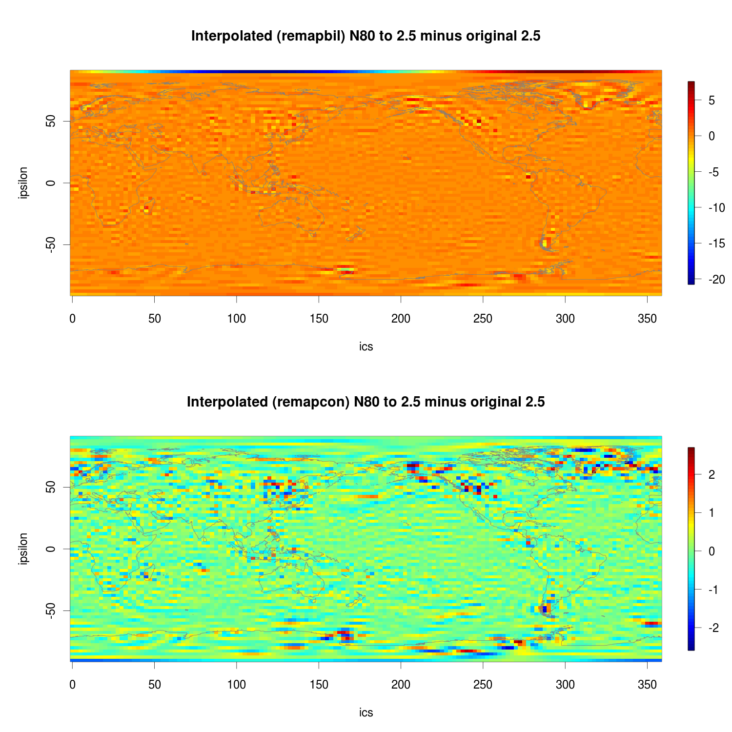
To give you some insight, here attached I plotted the differences between the original 2.5 field and the interpolated field from N80 grid.
First panel is remapbil, second panel is remapcon. As you can seen, the differences are important, and very big for the last latitude at the pole.
ERA40, Jan2000, U850.
All the best
Paolo
RE: remapbil and issues with high latitudes - Added by Uwe Schulzweida about 13 years ago
Dear Paulo,
U and V are derived from the model variables vorticity and divergence. vor and div are computed and stored in spectral space. There is a spectral transformation involved to derive U and V from vor and div. It could be possible that ECMWF have tools to do this transformation directly from N80 to a 2.5 grid. This would explain the difference.
Best regards,
Uwe
RE: remapbil and issues with high latitudes - Added by Paolo Davini about 13 years ago
Dear Uwe,
many thanks. This can really explain the differences that I get. Do you have any idea why there is this strong difference between the bilinear interpolation and the conservative remapping at the northest latitude?
Kind Regards
Paolo