How to interpolate data on curvilinear grid using remapdis into a lonlat grid with search radius 1.25 degrees
Added by Amit Kumar about 9 years ago
Hi all,
I'm trying to convert a curvilinear grid dataset into a lonlat grid dataset with grid size 2.5 degree. The resolution of curvilinear dataset is pixel level i.e. at nadir it is 4km but away it increases. Now for doing this I want to interpolate the curvilinear dataset by using remapdis but I want to change the search radius to 1.25 degrees. please help how to do it.
The output of sinfo of curvilinear file
File format : netCDF4 ZIP
    -1 : Institut Source   Ttype    Levels Num    Points Num Dtype : Parameter ID
     1 : unknown  IMAGER   instant       1   1   7898880   1  I16z : -1
     2 : unknown  IMAGER   instant       1   1   7898880   1  F32z : -2
   Grid coordinates :
     1 : curvilinear              : points=7898880 (2805x2816)
                        Longitude : 0.84 to 327.67 degrees_east
                         Latitude : -81.04 to 327.67 degrees_north
   Vertical coordinates :
     1 : surface                  : levels=1
   Time coordinate :  1 step
     RefTime =  2000-01-01 00:00:00  Units = minutes  Calendar = standard
  YYYY-MM-DD hh:mm:ss  YYYY-MM-DD hh:mm:ss  YYYY-MM-DD hh:mm:ss  YYYY-MM-DD hh:mm:ss
  0412-12-19 01:46:32
cdo sinfo: Processed 2 variables over 1 timestep ( 0.22s )
the grid i want to use:
gridtype = lonlat
gridsize = 525
xname = lon
xlongname = longitude
xunits = degrees_east
yname = lat
ylongname = latitude
yunits = degrees_north
xsize = 25
ysize = 21
xfirst = 40
xinc = 2.5
yfirst = -20
yinc = 2.5
Replies (12)
RE: How to interpolate data on curvilinear grid using remapdis into a lonlat grid with search radius 1.25 degrees - Added by Ralf Mueller about 9 years ago
Try
cdo remapdis,griddes.txt <inputfile> <outputfile>
where griddes.txt contains
gridtype = lonlat gridsize = 525 xname = lon xlongname = longitude xunits = degrees_east yname = lat ylongname = latitude yunits = degrees_north xsize = 25 ysize = 21 xfirst = 40 xinc = 2.5 yfirst = -20 yinc = 2.5
If the results or sufficient for you, you have to decide yourself.
hth
ralf
RE: How to interpolate data on curvilinear grid using remapdis into a lonlat grid with search radius 1.25 degrees - Added by Amit Kumar about 9 years ago
Hi Ralf,
I have done this but the issue is that I'm not able to change the default grid search radius from 180 degrees to 1.25 degrees.
RE: How to interpolate data on curvilinear grid using remapdis into a lonlat grid with search radius 1.25 degrees - Added by Ralf Mueller about 9 years ago
could you upload your data?
RE: How to interpolate data on curvilinear grid using remapdis into a lonlat grid with search radius 1.25 degrees - Added by Amit Kumar about 9 years ago
Hi Ralf,
Actually the size of data was exceeding the limit so i've used sellonlatbox to cut it down. I'm uploading the smaller file.
cdo sellonlatbox,-20,20,60,90 W_OLR_INT.nc W_OLR_INT_CUT.nc
cdo sinfo W_OLR_INT_CUT.nc
File format : netCDF4
-1 : Institut Source Ttype Levels Num Points Num Dtype : Parameter ID
1 : unknown IMAGER instant 1 1 22148 1 F32 : -1
Grid coordinates :
1 : curvilinear : points=22148 (226x98)
Longitude : 10.42 to 327.67 degrees_east
Latitude : 55.41 to 327.67 degrees_north
Vertical coordinates :
1 : surface : levels=1
Time coordinate : 1 step
RefTime = 2000-01-01 00:00:00 Units = minutes Calendar = standard
YYYY-MM-DD hh:mm:ss YYYY-MM-DD hh:mm:ss YYYY-MM-DD hh:mm:ss YYYY-MM-DD hh:mm:ss
0412-12-19 01:46:32
cdo sinfo: Processed 1 variable over 1 timestep ( 0.01s )
now i want to regrid it to a lonlat grid using remapdis, but i want to use grid search radius as 1.25 degrees instead of default 180 degrees.
| W_OLR_INT_CUT.nc (460 KB) W_OLR_INT_CUT.nc |
RE: How to interpolate data on curvilinear grid using remapdis into a lonlat grid with search radius 1.25 degrees - Added by Amit Kumar about 9 years ago
Hi Ralf,
By mistake i interchanged lat and lon values in sellonlatbox in the previous upload. I'm reattaching the file after doing correction.
cdo sellonlatbox,60,90,-20,20 W_OLR_INT.nc W_OLR_INT_CUT.nc
cdo sinfo W_OLR_INT_CUT.nc
File format : netCDF4
-1 : Institut Source Ttype Levels Num Points Num Dtype : Parameter ID
1 : unknown IMAGER instant 1 1 864821 1 F32 : -1
Grid coordinates :
1 : curvilinear : points=864821 (809x1069)
Longitude : 58.18 to 90.6 degrees_east
Latitude : -20.32 to 20.32 degrees_north
Vertical coordinates :
1 : surface : levels=1
Time coordinate : 1 step
RefTime = 2000-01-01 00:00:00 Units = minutes Calendar = standard
YYYY-MM-DD hh:mm:ss YYYY-MM-DD hh:mm:ss YYYY-MM-DD hh:mm:ss YYYY-MM-DD hh:mm:ss
0412-12-19 01:46:32
cdo sinfo: Processed 1 variable over 1 timestep ( 0.07s )
now i want to regrid it to a lonlat grid using remapdis, but i want to use grid search radius as 1.25 degrees instead of default 180 degrees.
| W_OLR_INT_CUT.nc (16.6 MB) W_OLR_INT_CUT.nc |
RE: How to interpolate data on curvilinear grid using remapdis into a lonlat grid with search radius 1.25 degrees - Added by Ralf Mueller about 9 years ago
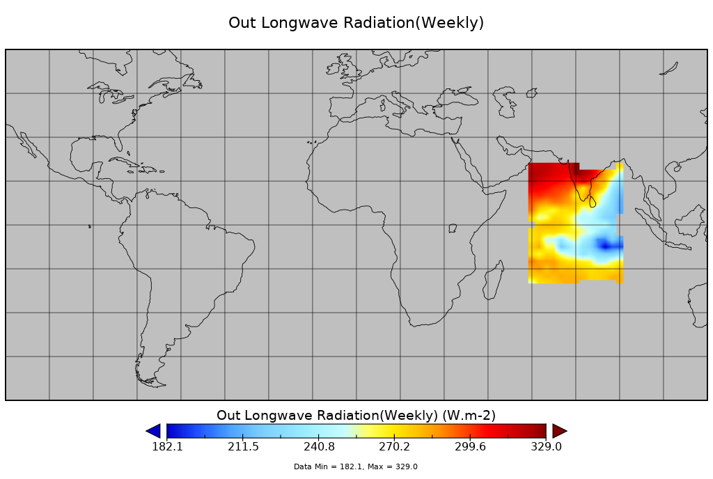
ok, here is what I did
cdo remapdis,gd W_OLR_INT_CUT.nc plainDis.nc |
CDO_GRIDSEARCH_RADIUS=1.25 cdo -v remapdis,gd W_OLR_INT_CUT.nc Radius1.25_Dis.nc |
 |
 |
Bilinear remapping works, too
cdo -v remapbil,gd W_OLR_INT_CUT.nc plainBilinear.nc
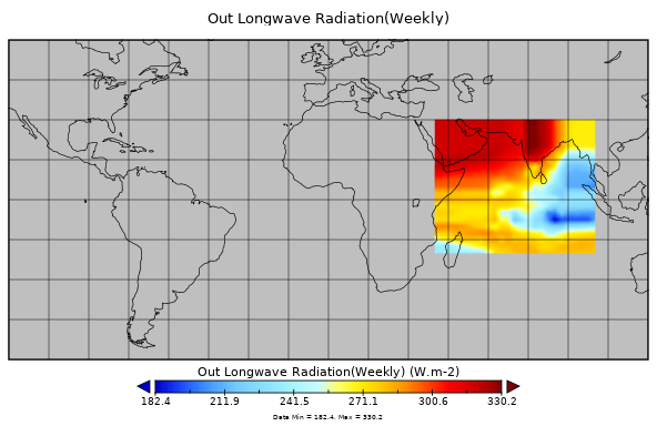
your original data looks like this:

| plainDis.nc (42.4 KB) plainDis.nc | |||
| Radius1.25_Dis.nc (42.4 KB) Radius1.25_Dis.nc | |||
| OLR_INT_Radius1.25_Dis.png (46.2 KB) OLR_INT_Radius1.25_Dis.png | |||
| OLR_INT_plainDis.png (52.3 KB) OLR_INT_plainDis.png | |||
| OLR_INT_plainBilinear.png (95.9 KB) OLR_INT_plainBilinear.png | |||
| originalData_W_OLR_INT_CUT.png (306 KB) originalData_W_OLR_INT_CUT.png |
RE: How to interpolate data on curvilinear grid using remapdis into a lonlat grid with search radius 1.25 degrees - Added by Amit Kumar about 9 years ago
Hi Ralf,
Thanks for your quick reply.
I have one doubt, in plainDIS interpolation the search radius is 180 degrees and in Radius1.25_Dis search radius is 1.25, then why both files have same values at the grid points. There should be a difference as the number of points used for interpolation in Radius1.25_Dis should be less than plainDIS.
RE: How to interpolate data on curvilinear grid using remapdis into a lonlat grid with search radius 1.25 degrees - Added by Ralf Mueller about 9 years ago
some clarification:
- the grid description fully describes the location of grid points. If you want to change THIS, you have to use a different grid
- interpolation methods (dis,bil, Radius to look for data) controls, what data is written to a grid point, I you lower the radius, less data values will be taken into account for compute the target value.
in your case the reduction of the radius leads to missing values, because some (outer) target locations are not covered with source data (wrt radius):
<ram@luthien:~/Downloads>
% cdo infov Radius1.25_Dis.nc
    -1 :       Date     Time   Level Gridsize    Miss :     Minimum        Mean     Maximum : Parameter name
     1 : 0412-12-19 01:46:32       0      525     300 :      182.38      269.88      330.20 : OLR_INT
cdo infon: Processed 525 values from 1 variable over 1 timestep ( 0.00s )
<ram@luthien:~/Downloads>
% cdo infov plainDis.nc
    -1 :       Date     Time   Level Gridsize    Miss :     Minimum        Mean     Maximum : Parameter name
     1 : 0412-12-19 01:46:32       0      525       0 :      182.38      277.08      330.20 : OLR_INT
cdo infon: Processed 525 values from 1 variable over 1 timestep ( 0.00s )
as you can see: missing values with smaller radius. you can see them with ncview very easily.
RE: How to interpolate data on curvilinear grid using remapdis into a lonlat grid with search radius 1.25 degrees - Added by Ralf Mueller about 9 years ago
your original data does not fit in to a regular lonlat box, so your will have missing values for a small (enough) raduis
RE: How to interpolate data on curvilinear grid using remapdis into a lonlat grid with search radius 1.25 degrees - Added by Amit Kumar about 9 years ago
exactly ralf, when the search radius is reduced then the number of points taken in consideration should reduce, but in this case take any point where values are available, either in center or corners they are having same values of OLR in both plainDIS and Radius1.25_Dis files, they show no difference because of change in search radius.
RE: How to interpolate data on curvilinear grid using remapdis into a lonlat grid with search radius 1.25 degrees - Added by Ralf Mueller about 9 years ago
Now I see, I thought you wondered about the equal horizontal grids.
I can confirm that behaviour, i.e. the equality of the inner values in both regridded files. Have to look it up - to me, it does not look correct or even desirable.
cheers
ralf
RE: How to interpolate data on curvilinear grid using remapdis into a lonlat grid with search radius 1.25 degrees - Added by Amit Kumar almost 9 years ago
Thanks Ralf,
I Will be waiting for hearing from you on this .......