How to mask .nc file from shape file?
Added by Juliana Freitas Santos almost 5 years ago
Hi all,
I am currently trying to mask a .nc data from a shapefile and ended up been directed to this old forum discussion "https://code.mpimet.mpg.de/boards/2/topics/6693". Everything is well explained and clear, so I followed it. Unfortunetaly, I am stuck in the first steps. Somehow I am unable to load the script "shapefile_utils.ncl". It always says "command not found". I am almost sure I am typing the write command:
load "$HOME/NCL/shapefiles/shapefile_utils.ncl"
I even tried from my personal directory in my project's account at dkrz (I have copied the .ncl script to my directory and also to the $HOME directory). It still says "command not found". Is there something that I am missing? Perhaps I am loading ncl wrong. I don't know, please any help would be very appreciated. Thank you!
Best,
Juliana
Replies (7)
RE: How to mask .nc file from shape file? - Added by Karin Meier-Fleischer almost 5 years ago
Hi Juliana,
you have to download it from https://www.ncl.ucar.edu/Applications/Scripts/shapefile_utils.ncl and e.g. save it in $HOME/NCL/shapefiles/. It is not really part of the official NCL software.
-Karin
RE: How to mask .nc file from shape file? - Added by Juliana Freitas Santos almost 5 years ago
Hi Karin,
thank you for you response. Yes, I believe I did all that but still retrieving the same issue. Please see image attached. Maybe I am doing something wrong because I've never worked with ncl before.
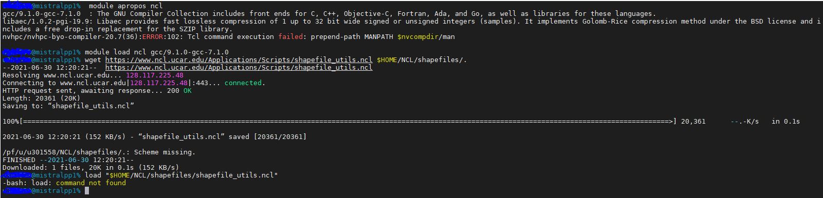
RE: How to mask .nc file from shape file? - Added by Karin Meier-Fleischer almost 5 years ago
You can't load the file shapefile_utils.ncl in the terminal, you have to run an NCL script containing the load command with 'ncl your-script.ncl' in your terminal.
If you are not familiar with NCL read the NCL User Guide https://www.ncl.ucar.edu/Document/Manuals/NCL_User_Guide.
You can find an article about masking with shapefiles in our DKRZ vis blog https://www.dkrz.de/up/services/analysis/visualization/vis-blog/convert-an-esri-shapefile-into-a-netcdf-file.
RE: How to mask .nc file from shape file? - Added by Juliana Freitas Santos almost 5 years ago
- ------------- REPOSTING, accidentaly deleted ------------##
Hi Karin,
thank you for you response. Yes, I believe I did all that but still retrieving the same issue. Please see image attached. Maybe I am doing something wrong because I've never worked with ncl before.
ANSWER:
You can't load the file shapefile_utils.ncl in the terminal, you have to run an NCL script containing the load command with 'ncl your-script.ncl' in your terminal.
If you are not familiar with NCL read the NCL User Guide https://www.ncl.ucar.edu/Document/Manuals/NCL_User_Guide.
You can find an article about masking with shapefiles in our DKRZ vis blog https://www.dkrz.de/up/services/analysis/visualization/vis-blog/convert-an-esri-shapefile-into-a-netcdf-file.
--Karin
RE: How to mask .nc file from shape file? - Added by Juliana Freitas Santos almost 5 years ago
New Problem!
Hi Karin,
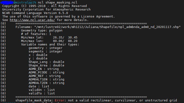
after figuring it out how the ncl runs scripts and adapting the following script to my data, I retrieve an error (see attached picture).
How can I fix it? Thank you for your support in this.
The script looks like this:
load "/mnt/lustre02/work/mh1212/Juliana/Shapefile/shapefile_utils.ncl" ;-- load additional lib
shp_name = "./npl_admbnda_adm0_nd_20201117.shp" ;-- shapefile name
mask_name = "./npl_mask.nc" ;-- output mask file name
print_shapefile_info(shp_name)
;-- open data file to get the grid to be used
f = addfile("./tas_Amon_CESM2_historical_r1i1p1f1_gn_195001-201012_May.nc", "r")
;-- read variable
v = f->tas
v@lat = f->lat
v@lon = f->lon
;-- resources for the shapefile_mask_data function
opt = True
opt@return_mask = True ;-- this forces the return of a 0s and 1s mask array
;-- create the mask based on the given shapefile; add coordinates
mask_array = shapefile_mask_data(v, shp_name, opt)
mask_array!0 = "lat"
mask_array!1 = "lon"
mask_array@coordinates = "lat lon"
;-- mask_array&lat = f->lat
;-- mask_array&lon = f->lon
;-- mask_array@comment = "Mask shapefile: npl_admbnda_adm0_nd_20201117.shp"
;-- set value 0 to missing value
mask_array = where(mask_array .eq. 1, mask_array, mask_array@_FillValue)
;-- delete, create, and write mask array to new file
system("rm f " + mask_name)>mask_array = mask_array
fout = addfile(mask_name,"c")
fout
fout->lat = f->lat
fout->lon = f->lon
------# Thank you!
RE: How to mask .nc file from shape file? - Added by Juliana Freitas Santos almost 5 years ago
Sorry, now the code in a more fashionable way:
load "/mnt/lustre02/work/mh1212/Juliana/Shapefile/shapefile_utils.ncl"  ;-- load additional lib

shp_name  = "/mnt/lustre02/work/mh1212/Juliana/Shapefile/npl_admbnda_adm0_nd_20201117.shp" ;-- shapefile name
mask_name = "/mnt/lustre02/work/mh1212/Juliana/Shapefile/npl_mask.nc"   ;-- output mask file name

print_shapefile_info(shp_name)

;-- open data file to get the grid to be used
f = addfile("/mnt/lustre02/work/mh1212/Juliana/Shapefile/tas_Amon_CESM2_historical_r1i1p1f1_gn_195001-201012_May.nc", "r")

;-- read variable
v     = f->tas
v@lat = f->lat
v@lon = f->lon

;-- resources for the shapefile_mask_data function
opt = True
opt@return_mask = True    ;-- this forces the return of a 0s and 1s mask array

;-- create the mask based on the given shapefile; add coordinates
mask_array         =  shapefile_mask_data(v, shp_name, opt)
mask_array!0       = "lat"
mask_array!1       = "lon"
mask_array@coordinates = "lat lon"
;-- mask_array&lat     =  f->lat
;-- mask_array&lon     =  f->lon
;-- mask_array@comment = "Mask shapefile: npl_admbnda_adm0_nd_20201117.shp"

;-- set value 0 to missing value
mask_array = where(mask_array .eq. 1, mask_array, mask_array@_FillValue)

;-- delete, create, and write mask array to new file
system("rm -f " + mask_name)
fout = addfile(mask_name,"c")
fout->mask_array = mask_array
fout->lat       =  f->lat
fout->lon     =  f->lon
RE: How to mask .nc file from shape file? - Added by Karin Meier-Fleischer almost 5 years ago
You are almost done. The variable tas has the dimensions tas(time, lat, lon) and shapefile_mask_data needs tas(lat,lon). You have to select one timestep first to create the mask file.
Here, we select the first timestep when reading the variable from file:
load "/mnt/lustre02/work/mh1212/Juliana/Shapefile/shapefile_utils.ncl"  ;-- load additional lib

shp_name  = "/mnt/lustre02/work/mh1212/Juliana/Shapefile/npl_admbnda_adm0_nd_20201117.shp" ;-- shapefile name
mask_name = "/mnt/lustre02/work/mh1212/Juliana/Shapefile/npl_mask.nc"   ;-- output mask file name

print_shapefile_info(shp_name)

;-- open data file to get the grid to be used
f = addfile("/mnt/lustre02/work/mh1212/Juliana/Shapefile/tas_Amon_CESM2_historical_r1i1p1f1_gn_195001-201012_May.nc", "r")

;-- read variable
v     = f->tas(0,:,:)
v@lat = f->lat
v@lon = f->lon

;-- resources for the shapefile_mask_data function
opt = True
opt@return_mask = True    ;-- this forces the return of a 0s and 1s mask array

;-- create the mask based on the given shapefile; add coordinates

mask_array         =  shapefile_mask_data(v, shp_name, opt)
mask_array!0       = "lat"
mask_array!1       = "lon"
mask_array@coordinates = "lat lon"

;-- set value 0 to missing value
mask_array = where(mask_array .eq. 1, mask_array, mask_array@_FillValue)

;-- delete, create, and write mask array to new file
system("rm -f " + mask_name)
fout = addfile(mask_name,"c")
fout->mask_array = mask_array
fout->lat        =  f->lat
fout->lon        =  f->lon
The generated mask file looks like this:
netcdf npl_mask {
dimensions:
    lat = 192 ;
    lon = 288 ;
variables:
    int mask_array(lat, lon) ;
        mask_array:coordinates = "lat lon" ;
        mask_array:_FillValue = -2147483647 ;
    double lat(lat) ;
        lat:standard_name = "latitude" ;
        lat:long_name = "latitude" ;
        lat:units = "degrees_north" ;
        lat:axis = "Y" ;
        lat:bounds = "lat_bnds" ;
    double lon(lon) ;
        lon:standard_name = "longitude" ;
        lon:long_name = "longitude" ;
        lon:units = "degrees_east" ;
        lon:axis = "X" ;
        lon:bounds = "lon_bnds" ;
}