remapcon limitations
Added by Brendan DeTracey over 3 years ago
Hi all,
I need to find the truth about the limitations of the remapcon command. I have abused this command to generate the area-weighted mean over polygons. In this thread [https://code.mpimet.mpg.de/boards/1/topics/12461?r=12463#message-12463] Uwe stated that for remapcon (or, more properly, the YAC coupler code) to give proper results the grid cells must be strictly convex. The attached image illustrates the nature of my polygons, which are not convex. I need to know 100% whether remapcon results for polygons such as these are incorrect, along with a guess of how incorrect they might be. The results have already been published in an internal technical report and a paper is pending.
The initial project was so successful that I have now been tasked with repeating my calculations (  ) for many more such polygons and these new polygons are even more complex that the ones in my figure. I realize I may instead have to use the
 selregion command for my future calculations. The beauty of remapcon is that, ideally, it was weighting and normalizing the model results over the same geographic area. I was using this to trim ocean model grid cell along the shelf break, to get values more appropriate to the continental shelf.
EDIT: text from the YAC paper
"The clipping of two polygons computes the intersection
between them. Typical clipping algorithms assume that all
edges of the polygons are straight lines. Due to the type
of edges supported by YAC, this is not the case here. We
have tried to approximate the latitude circle edges using
sections of great circles, but this increases computation time and
makes the cell concave even though in latitude–longitude
space it is convex. Currently, we use a modified version
of the Sutherland–Hodgman clipping algorithm (Sutherland
and Hodgman, 1974). This algorithm requires that one cell is
either a convex cell that has only great-circle edges or a
rectangular cell consisting of latitude and longitude circle edges.
The second cell can be either convex or concave and can have
any combination of edge types."
My interpretation of this is that my results should be okay. My polygons are not convex, but the ocean model grids cells are.
Thank-you!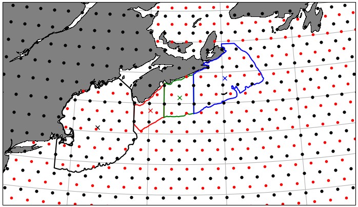
Replies (9)
RE: remapcon limitations - Added by Ralf Mueller over 3 years ago
Hi Brendan!
I think with some real input data it would be easier to identify possible problems. Can you provide maybe one critical region file?
Another issue might be the input grid of the data. is it a regular lonlat grid as you show in the image above?
cheers
ralf
RE: remapcon limitations - Added by Brendan DeTracey over 3 years ago
Hi ralf!
I have attached all four of my target grids. Each is a single grid cell (polygon) in SCRIP format. As for the source grid, the source grid could be any of the CMIP6 ocean grids. I will provide one time step from one of the ACCESS models, because the ACCESS group made proper CF/CMIP6 compliant ocean output. (Sadly most groups did not do this. Most of the CMIP6 ocean grids are non-compliant. It is a continual headache.)
Danke,
Brendamn
Edit: And for the record, I think someone should just ask Moritz Hanke, since YAC is his code.
RE: remapcon limitations - Added by Ralf Mueller over 3 years ago
thx for the uploads. So I assume your current workflow looks like
cdo remapcon,cdo_scrip_grid_css.nc tos_Omon_ACCESS-CM2_historical_r1i1p1f1_gn_195001.nc tos_in_css_cell.nc
and the alternative would be
- create an ascii-polygon file from cdo_scrip_grid_css.nc (like
css-region.txt) cdo -selregion,css-region.txt tos_Omon_ACCESS-CM2_historical_r1i1p1f1_gn_195001.nc tos_in.css_region.nc- compute statitics for this region on the original grid from the
tosfile
did I get it right?
I will contact Moritz
RE: remapcon limitations - Added by Brendan DeTracey over 3 years ago
Hey ralf,
Yes. That is what I am doing, and your selregion command is what I might have to do in the future. I have concerns the selregion command might end up as a debugging exercise, because of the nature of the ocean grids. (Also, I don't know how flexible selregion is to regions crossing the antimeridian e.g. ocean source grid is [-180,180) in longitude but the selregion polygon longitude range is [175,185])
EDIT: strike that last bit. Just checked Selregion.cc and it looks like it covers that condition.
RE: remapcon limitations - Added by Ralf Mueller over 3 years ago
Hi again!
I had a long debugging session with Moritz and our analysis of the current 2.1.0 release version (yac did not change in the last releases AFAIK) is this:
- the clipping algorithm does a triangulation based on the given cell center of your region
- for convex cells this works
- non-convex cells, which have the property that every connection from the cell center each of the corners is part of the cell also work
- completely arbitrary cell shapes do not work, because the triangulation leads to triangles that to not fully overlap with the original cell
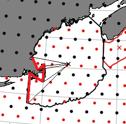
Hence, you should get errors with shapes that are critical. possible with something like this:
We also checked the cell area computation, which is used to normalize the individual weights wrt. to the source cells. This computation does take into account, that some triangles might partly lay outside the original cell. So it should be ok for critial shapes.
So much for what the code should be able to do ...
Finally we tested all 4 regions with a constant regular grided field like this:
cdo -info -remapcon,cdo_scrip_grid_ess.nc -const,1.0,global_0.1
In case the weight computation does not work for your regions, some areas should have been counted multiple times, which should lead to value != 1.0. This final values includes weight computation (which should give wrong results) and normalization (which should be ok for your regions). Hence we expected values != 1.0, but we only got 1.0 for all 4 inputs:
% cdo -s -info -remapcon,cdo_scrip_grid_css.nc -const,1.0,global_0.1                               [Thu 2022-10-20|14:26:13]
    -1 :       Date     Time   Level Gridsize    Miss :     Minimum        Mean     Maximum : Parameter ID
     1 : 0001-01-01 00:00:00       0        1       0 :                  1.0000             : -1
% cdo -s -info -remapcon,cdo_scrip_grid_ess.nc -const,1.0,global_0.1                               [Thu 2022-10-20|14:26:21]
    -1 :       Date     Time   Level Gridsize    Miss :     Minimum        Mean     Maximum : Parameter ID
     1 : 0001-01-01 00:00:00       0        1       0 :                  1.0000             : -1
% cdo -s -info -remapcon,cdo_scrip_grid_wss.nc -const,1.0,global_0.1                               [Thu 2022-10-20|14:26:33]
    -1 :       Date     Time   Level Gridsize    Miss :     Minimum        Mean     Maximum : Parameter ID
     1 : 0001-01-01 00:00:00       0        1       0 :                  1.0000             : -1
% cdo -s -info -remapcon,cdo_scrip_grid_gom.nc -const,1.0,global_0.1                               [Thu 2022-10-20|14:26:38]
    -1 :       Date     Time   Level Gridsize    Miss :     Minimum        Mean     Maximum : Parameter ID
     1 : 0001-01-01 00:00:00       0        1       0 :                  1.0000             : -1
To me this a good but surprising results. Of course it strongly depends on the input shapes, which I did not investigate any further.
Possible next steps:
- Create artificial non-convex inputs and check CDOs behaviour on those. This might give a better understanding of the size of the possible error. Instead of remapping the fields we can check the weight computation instead with the
genconoperator. - Check the difference of the results when using the alternative
selregion-based workflow: Since selregion does not involve any interpolation, you might considerable change the data-area compared to your target region. That's why I think it's pretty natural to involve remapping here. But I agree: The errors must be analyzed. - Replace the input region polygons with a (possible unstructured) grid that has only convex cells. Such an input is supposed to work with CDO. You can create such coordinates with libraries like http://gamma.cs.unc.edu/SEIDEL/ or with python's matplotlib like here . Conservative remapping works fine with unstructured grids like this.
Sorry, Brendan, for the inconclusive first answer. I will create an artificial grid like a U and rerun the above tests.
cheers
ralf
| critical-shape.png (60.1 KB) critical-shape.png |
RE: remapcon limitations - Added by Brendan DeTracey over 3 years ago
ralf,
thanks so much for all your time on this. I had a bad feeling that the correct answer would be to break my existing polygons into a triangular mesh, which is really far too much work for the precision required. I think I will have to move on to using selregion. My original goal was to weight ocean grid cells by how much of them was on the shelf. I will surrender this goal. The good news is that my work was based on changes, so even if the answers had slightly bad area normalization, the error should be reduced in the taking of differences.
Thanks again!
Brendan
RE: remapcon limitations - Added by Ralf Mueller over 3 years ago
Hi again!
We will investigate further and maybe we can provide a conservative interpolation to non-convex cells in the future. For you workflow though selregion might be the better solution at the moment. I think the precision issue is highly related to the resolution of the source grid. It seems coarse compared to your polygon.
In order to work with something convex that also supports your polygon better you could
- interpolate your source data to much high regular resolution with conservative remapping (only a selection maybe to save some compute time and disk space
- fill the missing land values with something reasonable (at this point you are inventing data which is questionable) see https://code.mpimet.mpg.de/boards/2/topics/9978 or page 14+15 of https://code.mpimet.mpg.de/attachments/download/13557/CDO_Seminar_20161206.pdf
- apply
selregionon that
Results might look good, but creating data points like this needs extra thinking. We use similar techniques for model initialization files, which are on a much coarser grid than the model grid. The examples above are taken from this. They are about salinity values in the Baltic see, which are much lover compared to the north Atlantic.
thx for the interesting input - always good to learn something new about the limits of CDO
have a nice weekend!
cheers
ralf
RE: remapcon limitations - Added by Uwe Schulzweida about 3 years ago
CDO 2.1.1 uses YAC version 2.6.1. This YAC version also supports non-convex cells. With this version remapcon should work without problems with the above regions.