Convert curvilinear/rotated grid into regular grid
Added by sara Abdelaziz about 4 years ago
Hi, originally I have 2D NumPy array [606,484] (with no time dimnsion) that has been extracted from curvilinear/rotated grid and has similar specification to the grid in the file (wsgmax_wsgmax10m_rcp85_land-cpm_uk_2.2km_01_1hr_20610701-20610730_mask.nc). I tried different methods to regrid this NumPy array to a regular grid but none of them worked, finally, I decided to use CDO, so I converted my 2D array to NetCDF file (myfile.nc) and tried to apply:
cdo -remapnn,gridfile.txt myfile.nc mask_lonlat.nc
but I get error:
Warning (find_time_vars): Time variable >time< not found!
cdo remapnn (Abort): Unsupported generic coordinates (Variable: myvar)!
please can you assist? the mentioned files are in these links:
myfile.nc is in:
(https://drive.google.com/file/d/1ukG2EmLlaWNufw5ybati9atzKPSwChK_/view?usp=sharing)
wsgmax_wsgmax10m_rcp85_land-cpm_uk_2.2km_01_1hr_20610701-20610730_mask.nc is in:
(https://drive.google.com/file/d/1BHdWdBSmbAhPyZlyWJjbhflV_ldA3gVY/view?usp=sharing)
The gridfile.txt
gridtype = lonlat
gridsize = 293304
xsize = 484
ysize = 606
xname = longitude
xlongname = "longitude"
xunits = "degrees_east"
yname = latitude
ylongname = "latitude"
yunits = "degrees_north"
xfirst = -14.60127
xinc = 0.042931
yfirst = 47.42323
yinc = 0.021712
Replies (3)
RE: Convert curvilinear/rotated grid into regular grid - Added by Karin Meier-Fleischer about 4 years ago
Hi Abdelaziz,
the warning message tells you what is wrong - time is missing. But also the coordinate variables lon and lat do not have units attributes (like degrees_east and degrees_north). The best would be to write a correct netCDF file with your Python script (with time coordinate and all needed attributes), I recommend to use xarray.
You can can do theses things on the command line too, but it would be more effort and not sustainable.
-Karin
RE: Convert curvilinear/rotated grid into regular grid - Added by sara Abdelaziz about 4 years ago
Dear Karin,
Thank you for your reply,
I actually fixed the error that occurred when using:
cdo -remapnn,gridfile.txt myfile6.nc mask_lonlat.nc
but the result is completely unsatisfying, I am not sure where the problem is, can you assist, please?
Sara
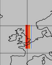
| plot.png (7.11 KB) plot.png | |||
| mask_lonlat.nc (2.26 MB) mask_lonlat.nc | |||
| myfile6.nc (2.25 MB) myfile6.nc |
RE: Convert curvilinear/rotated grid into regular grid - Added by Karin Meier-Fleischer about 4 years ago
I think your input data coordinates are wrong or the gridfile is wrong. The data doesn't fit to the gridfile lonlat range.
I can see Great Britain set around lon=0.0/lat=0.0 (looks like rotated grid).
cdo sinfon myfile6.nc
   File format : NetCDF4
    -1 : Institut Source   T Steptype Levels Num    Points Num Dtype : Parameter name
     1 : unknown  unknown  c instant       1   1    293304   1  F64  : myvar
   Grid coordinates :
     1 : lonlat                   : points=293304 (484x606)
                              lon : 353.9359 to 364.3055 degrees east
                              lat : -4.682749 to 8.062849 degrees north
   Vertical coordinates :
     1 : surface                  : levels=1
cdo remapnn,gridfile.txt myfile6.nc mask_lonlat.nc
cdo sinfon mask_lonlat.nc
   File format : NetCDF4
    -1 : Institut Source   T Steptype Levels Num    Points Num Dtype : Parameter name
     1 : unknown  unknown  c instant       1   1    293304   1  F64  : myvar
   Grid coordinates :
     1 : lonlat                   : points=293304 (484x606)
                        longitude : -14.60127 to 6.134403 by 0.042931 degrees_east
                         latitude : 47.42323 to 60.55899 by 0.021712 degrees_north
   Vertical coordinates :
     1 : surface                  : levels=1